
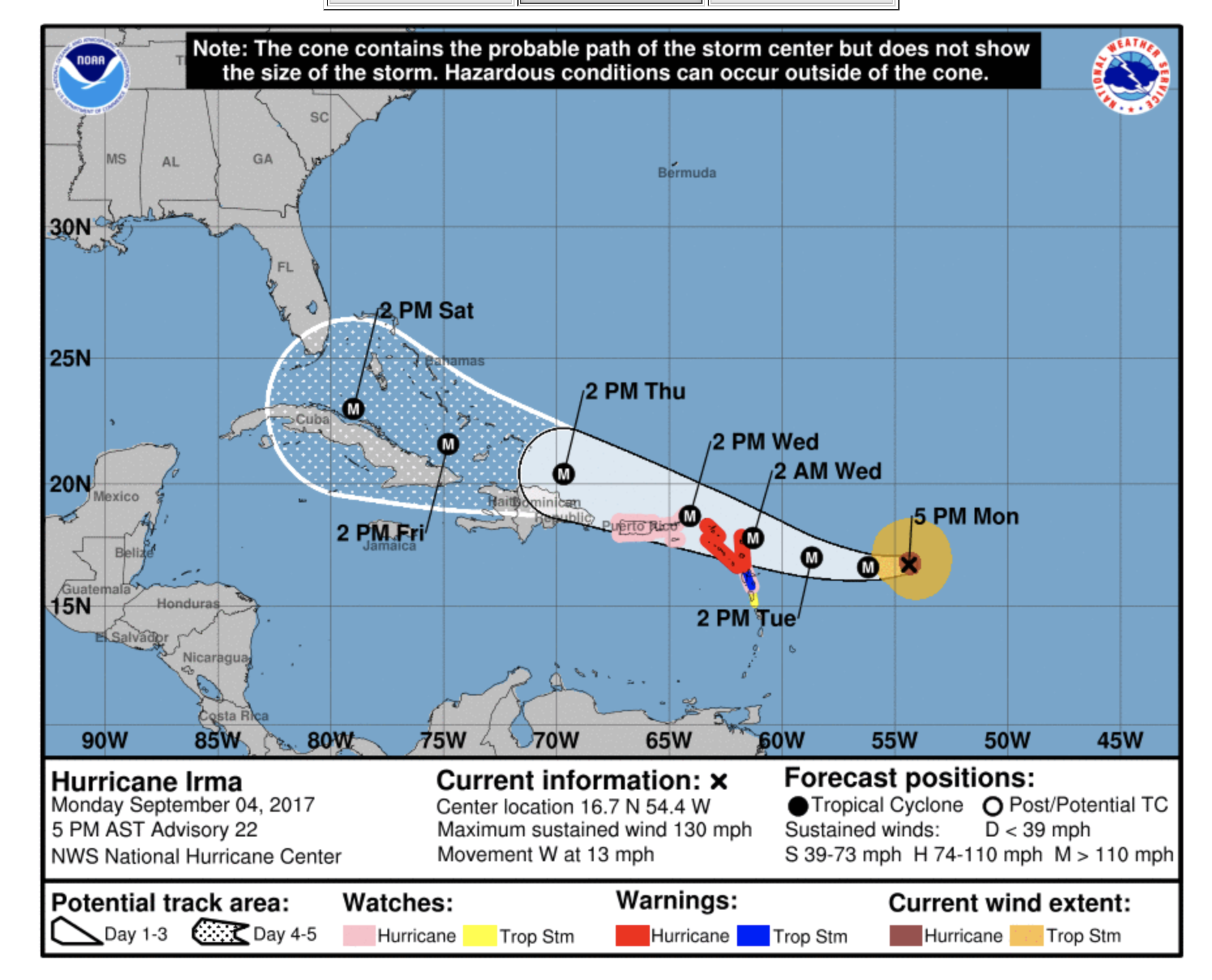
We know many are still dealing with the aftermath of Harvey – but we are now dealing with preparing for our own hurricane.
Yup, we are in Marathon, Florida – the Keys. We’ve been closely watching Irma since she was a little invest off the coast of Africa and up until now, most projections had the Keys with just possible tropical storm conditions.
But this morning’s projections now have us as a bullseye of a Cat 3 or 4 hurricane.
We’re still several days out, and things can change – but if we’re going to execute one of our options – time is ticking.
Our two top options are:
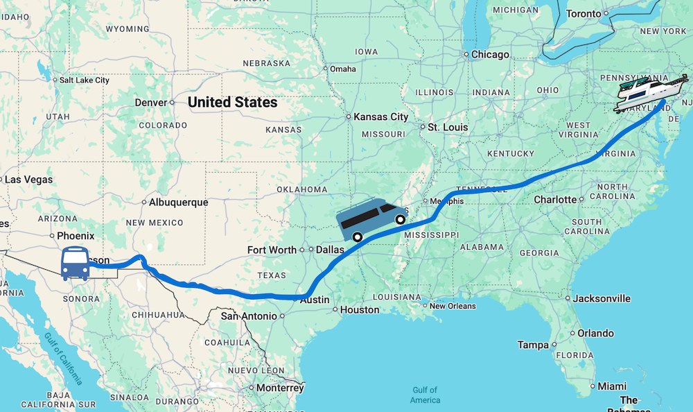
- Secure the boat in Marathon as best we can, and escape by land. We have access to a truck to pack things up and evacuate on our own schedule (thanks Randy!). We could even possibly pick up the bus in Melbourne and get out of Florida all together if conditions warrant it. Preps for securing are in progress so we keep that option open.
- Setting sail soon (tomorrow morning) for Marco Island / Ft. Myers and potentially the Okeechobee Waterway, which was our original intentions if Irma started shifting more our way. However, models have drastically shifted towards the west with probability increasing for a west coast strike too – so we have to carefully consider if this actually buys us any additional safety (maybe time?). It’s a good 2 day cruise at our speed back to where we left in early August.
It’s all a gamble. And as boating newbies, we do not feel confident to ride out the storm onboard. We’re looking for the options that keeps US the safest first.
Here’s a quick in the moment video update:
We knew this was a risk when we made the decision to stick in Florida during hurricane season – not that we had too many alternate options.
We are of course asking for your well wishes, and sending ours to all impacted too. We are also encouraging all to stand facing south and east and BLOW REALLY HARD. It may not do anything… but it can’t hurt, right?
What we are not asking for is “suggestions” or opinions on what we should do, or what you would do – no matter how well meaning they are. We can’t afford to second guess ourselves right now, and nor do we have the time to argue or explain the data points we’re working with, many of which we just don’t have time to document in a short update like this.
We are already processing a lot of data, have a lot of preps to get done and have trusted experienced folks we’re in touch with.
Note: We have shut off comments.. too many folks ignoring our request.
However, if you do have resources to offer us (we have no idea what those would be – a house to evacuate to? A magical air lift? a safe harbour? ability to control the weather, help out in person?) – please do be in touch.
Hi, Good Thoughts to y’all.
If it were me and mine, I think we would would make reservations at a marina as far up Western coast of Florida as possible and leave the boat. If it’s a bulls eye hit, ain’t nothing you can do but collect insurance and start shopping again, but if it goes north and east of the boat, with land between the storm and the boat the land mass may diminish the strength . If it were us, I think we would split up with one person ( and Kiki)
boating to the marina, the other would get to the bus, and meet the sailor at the marina, then drive Northwest out of and away from Florida.
That’s what I would do, y’all will make the best decision for y’all. But you are wise to consider that your options diminish with the passage of time. be safe.
Secure the boat in Marathon, take the bus and head north and inland swinging east or west depending on the ultimate track of Irma.
That’s what your boat insurance is for.
I’ve been through 4 major hurricanes in FL. If it hits the Keys, your boat is history no matter how well secured it might be.
My advice, for what it is worth, is get out of Dodge as soon as you can. If you wait too long, the roads are going to be a parking lot. The boat can be replaced, you can’t.
I don’t think you have two days to move your boat back north. The storm is a lot bigger than just the dot on the map. It a Cat 4 storm and is expected to stay that way as it nears Florida.
Will be thinking of you. Stay safe!!!
I am not a boater/sailor, but have backpacked hundreds of miles. In times like these go with your collective gut feeling. You will make it through.
BTW – I am blowing as hard as I can from So Cal. Feel the breeze? Is Irma shifting course?
I know you guys will make the best choice with the most up to date info you can get. Just sending good vibes your way for a safe departure whichever path you choose! You’re absolutely right though, you guys and Kiki are the most important priorities right now. The boat can be replaced. {hugs}
I pray you and your boat are safe from this storm. And others in this storms path also.
Praying for your safety and those who are in Irma’s path…. I’m certain that you will make the best decision for you…..I would suggest heading north and inland towards Nashville TN if you can start driving tomorrow, that would be great. There will be no safe place in FL or either gulf or east coast….the storm is huge and powerful. Hotels will be filling up quickly along the evacuation route. …… Keep us posted. Denise and Pete Lacharite
Stay safe Chris and Cherie!
You guys are smart, competent people. Trust your gut and know lots of us are thinking of you.
If it was me, With the storm a couple days out, I would, depending on fast that boat can get up and go, leave for further up the coast of Florida, as far as I could get. I have no idea how far your boat can get on a tank of fuel, but I would plan to get as far north as up that coast as I could.
Question is.. which coast? Models have it going up both coasts right now.
Your way down the Keys? for folks doing the great loop, you sure are spending a lot of time in Florida. You will own that boat for at least a few years after you finish the loop, do your exploring then. I have no idea how far north you intend to get this year, but time is of the essence here, because it gets very cold up north very quick, I know, I live in Canada, and the temp takes a dive after Our Thanksgiving, which is the 3rd weekend of October. And as Truck driver who has traveled the USA from coast to coast and through every state, it snows and freezes down to the Mason Dixon line, some place further down, some places way further up
We’re planning to do the Loop slowly, over several years – spending time along the way. May not be your choice, but that’s ours. When it gets cold, we store the boat and move back on the bus. Please check our past plans for the full details. Again, we asked for NO SUGGESTIONS in this post.
Glad your main focus is the safest route. Hope your able to secure both your boat & RV. We are still in hurricane Harvey recovery for family members & friends that flooded. We were at ground zero but we were able to get our RV out of flood danger & our sticks & bricks made it OK. Stay safe!
Glad the houses made it ok, and wishing you guys all the best in the recovery!
Where are you guys potentially thinking about going on the Okeechobee Waterway, if you head that way? We’re currently at Indiantown Marina and I think all of the slips are pretty much now all reserved. Not sure if there’s space at Glades still? I guess it’s hard to know what to do just now as the track is still uncertain for this neck of the woods. Hang in there. Not the best introduction to boating life 🙁
Yup, marina availability is a huge consideration in just staying here in Marathon. We have a call into Legacy (where we were in Ft. Myers) to see if they can take us or not.
Our thoughts are with you…. Stay safe!
Best of luck, whatever you decide!!!