• Skip to primary navigation
  • Skip to main content
  • Skip to primary sidebar
  • Skip to footer
Technomadia

Technomadia

Adventures in Nomadic Serendipity

  • Blog
  • Video
  • Technology
    • Mobile Technology
    • Solar Electrical System
    • Lithium Ion Batteries
    • Mobile Internet Setup
    • Mobile Internet Resource Center (Our Work)
  • Nomad
    • No Excuses: Go Nomadic Series
    • Nomadic Lifestyle Featured Posts
    • Travel Maps, Annual Wraps-Ups & Plans
    • Fitness on the Road/Water
    • Cost Log
    • Kiki’s Corner (RIP: 2008 – 2024)
  • RVing
    • Zephyr – 1961 Bus Conversion
    • Blooper – 2020.5 Winnebago Travato 59GL Van Conversion
    • Bus Projects
    • RVing Lifestyle Featured Posts
    • RVing Travelogues
  • Boating
    • Y-Not — 1999 Bayliner 4788 Motor Yacht
    • Boat Projects
    • Cruising Lifestyle Featured Posts
    • Cruising Travelogues
    • Great Loop Map & Posts
    • St. Johns River Cruising
  • About Us
    • Start Here – Quick Intro
    • Our Full Story
    • “Technomedia” (Media Appearances)
    • Say Thanks
    • Contact Us

Arriving to the Keys – Pre-Irma Marathon

Cruising / Boating (March 2017 - present) Travelogues

Nov 10, 2017 by Cherie Ve Ard 13 Comments

Ok.. time warp time again, this time taking you back to mid-August and our arrival to the Keys, and our time there before Hurricane Irma! I promise you, we’re working to get the travelogue caught up to real time!  Thanks for hanging out with us!

When we last ended our Great Loop travel journal entry, we had just finished exploring Ten Thousand Islands and Everglades National Park on our way to the Keys.

This post covers the time span of August 18 up until our evacuation on September 5.

Arriving to Marathon, FL

As always, the video version (this time just under 9 minutes):

Stop 1: Molasses Key

Our Navionics plotting — 31.7 nm from Cape Sable to Molasses Key. Cruising Time: 4.2 hours.

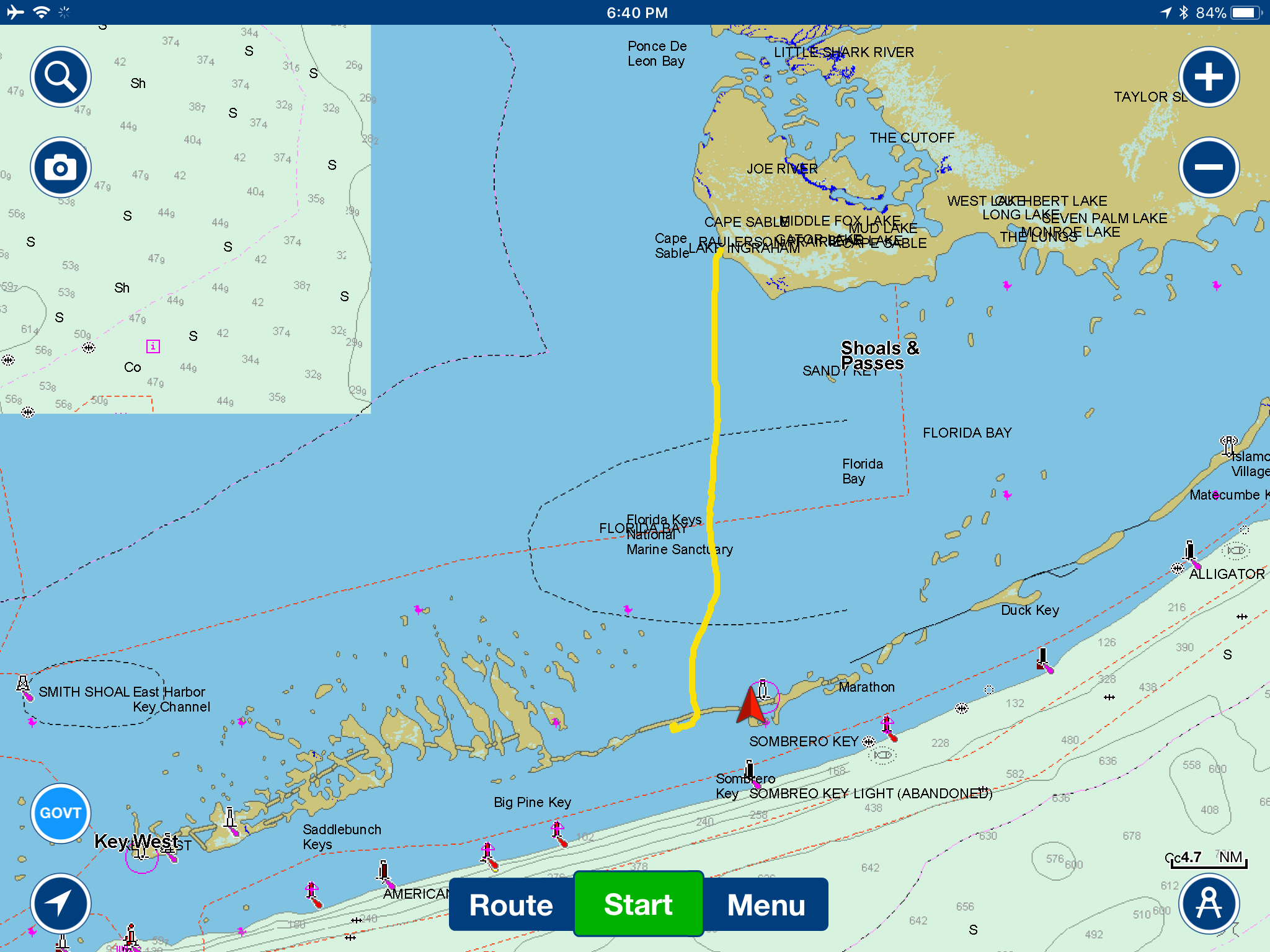
There are multiple ways boats get from the Everglades to the Keys.

The Yacht Channel takes you more northward around the tip of south Florida and into Islamorada – and is ideal for boats like ours with a shallow draft due to lots of shoaling. For deeper boats, a direct passage between Cape Sable and Vaca Key (where Marathon is located) comes right under the 7-Mile Bridge. And others elect to go even more open water and head straight for Key West.

We opted for the middle route – mainly because we had a blog reader who manages a marina who had invited us to drop by for a visit. Marathon seemed like a nice central location re-provision, get the lay of the land and explore the Keys from.

So, our destination was set with about a 30 mile passage ahead of us.

We wanted our first taste of the Keys to be at anchor and do a bit of snorkeling off our own boat. Ideally, we would have spent a few days at anchor – but we were already getting itchy for easy walking, re-provisioniong and there was unsettled weather coming in.

There were also multiple tropical invests closing in that we were keeping a close eye on.

The closest anchorage was just a slight diversion to the south after we crossed to the ocean side of the 7-mile bridge – so we settled in for the night at Molasses Key. We got a little snorkeling in, but our anchor was not holding firmly on the ocean floor.

Molasses Key
Molasses Key
Drone Pilot
Drone Pilot
Happy Captains
Happy Captains
DCIM100MEDIADJI_0520.JPG

With each tidal current shift, we’d drag a few dozen feet.  After the experience we had at Cape Sable the night before as we took ricocheting waves to the beam – we were both tired and craving sleep, but were on hyper alert all night as a small storm cell moved through. Aside from some anchor dragging, we did fine.

By day break, we were more than ready to move on to the protected Boot Key Harbor tied up to a marina, and get a few good night’s sleep.

Stop 2: Burdines Marina

Our Navionics plotting — 5.6 nm from Molasses Key to Burdines. Cruising Time: 1 hour.

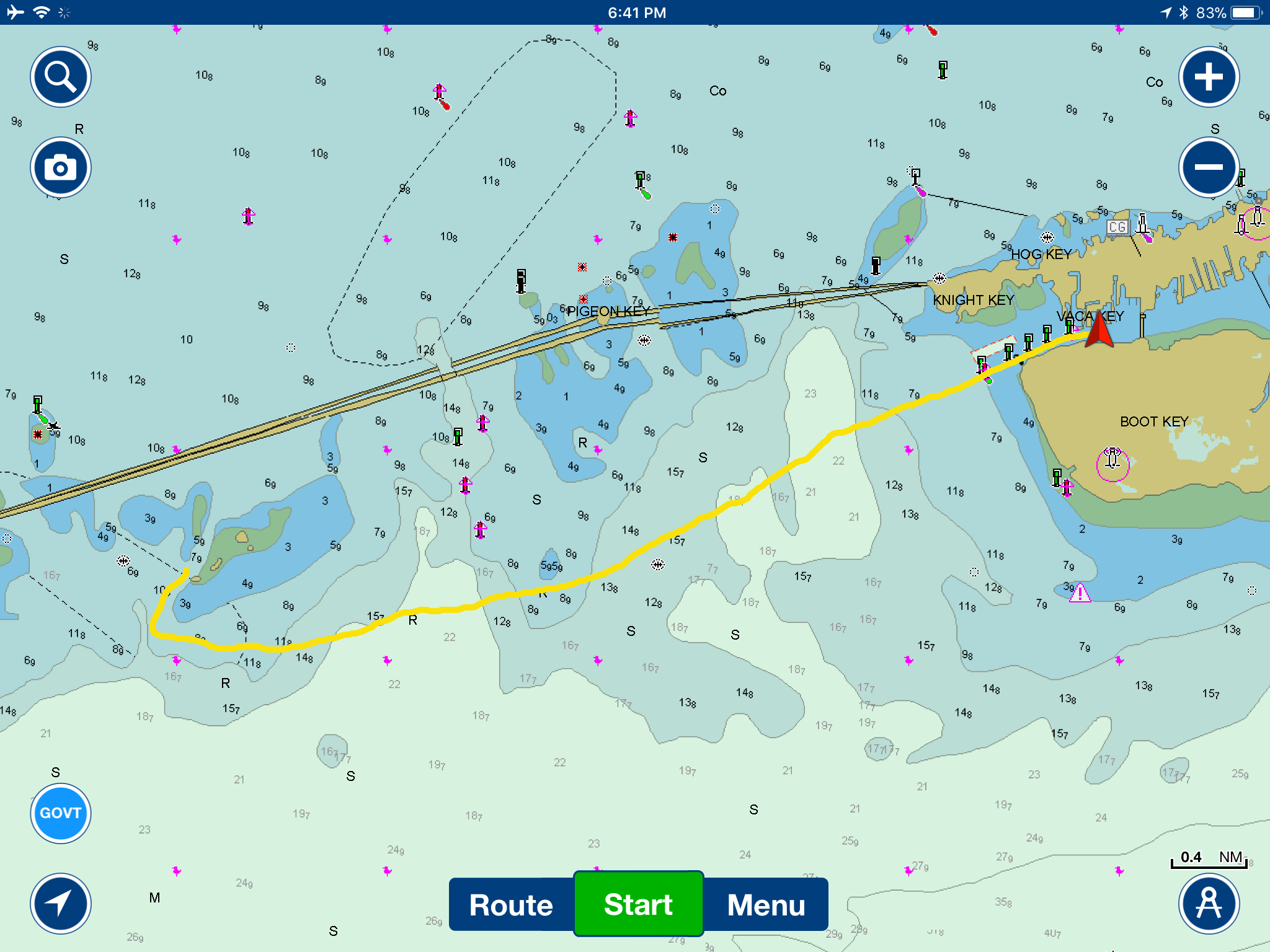
I remember the e-mail well, a sincerely written invitation for a few days of dockage at Burdines Waterfront Marina in Marathon from a long time blog follower – Randy. We always love meeting up with folks in our travels, and after a couple weeks basically on our own – we were ready to be around people.

Randy had the first slip in his marina ready for us – an extra wide 22′ slip with a clear view of open water. We pulled straight in with our aft windows surrounded by glorious views.

We got to know the staff at Burdines over sharing the eclipse together, and really enjoyed getting to know Randy.

He made us an off-season offer to use Burdines as our base camp up until November as he had wide open availability.

Since we had just made connections with SALT Marine down the road – a marine solar specialist available to approach our solar & lithium upgrade – we set intentions to do just that. We also enjoyed getting to know SALT’s founder Bob and his wife Lucia socially.

We started to settle into a pattern of enjoying delicious food off our bow at the infamous Burdines Waterfront Chiki Tiki Bar & Grille, exploring other local fare and dipping our toes into the tourist attractions & community.

We explored Boot Key Harbor, Whiskey Creek and Sombrero Beach by dinghy.

And we walked down the road to pay a visit to the Turtle Hospital, an amazing non-profit rescuing and healing injured sea turtles.

IMG_9795
Dining at Burdines
Dining at Burdines
Solar Eclipse
Solar Eclipse
Sombrero Beach
Sombrero Beach
Boot Key Habor
Boot Key Habor
Key Deer
Key Deer
Turtle Hospital
Turtle Hospital
Turtles!
Turtles!
Getting the hurricane lines out…

We made a list of other things we wanted to do – Pigeon Key, Dolphin Research Center and perhaps some boating excursions for more snorkeling and a trip down to the Keys (and Dry Tortugas).

But then.. we woke up at 5am on September 4 to the updated tropical weather forecast that changed everything for us. Irma had other plans.

At this point, we pre-empted the travelogue and switched to real time reporting for our evacuation.

We’ll get a re-cap of that out next, along with the specific boat preps we made before leaving Y-Not behind in Marathon for a catastrophic hurricane.

Great Loop Log (9/5/2017)

  • Distance: 231.2 nm
  • Stops: 16
  • Marina Nights: 115
  • Anchored Nights: 15
  • Bridges : 11 
  • Locks: 0

Other Travel Posts in this Great Loop Travel Series:

  • South to the Keys:
    • The Great Loop: South to the Keys (Part 1) — Ft. Myers to Naples
    • The Great Loop: South to the Keys (Part 2) — Naples to Marco Island
    • The Great Loop: South to the Keys (Part 3) — Cruising Ten Thousand Islands
    • The Great Loop: South to the Keys (Part 4) — Everglades National Park — Little Shark River & Cape Sable
  • Sometimes Nomads Need to Grow Some Barnacles (Two Months in Fort Myers)
  • Starting the Great Loop — First Adventure: Punta Gorda, FL to Fort Myers, FL

View all our Great Loop Posts
on our new Interactive Map!

Current Status:

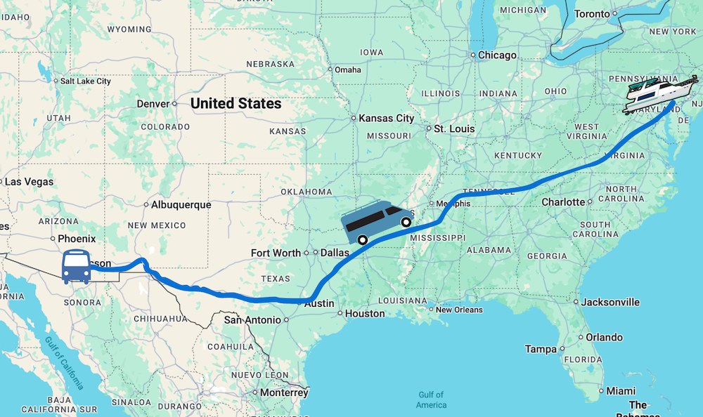
We updated last week about our little incident with a submerged channel marker just as we were exiting the Keys (literally.. it was the first channel marker into Biscayne Bay! Oh, the irony!).

We are now hauled out at SeaLab Marina in Miami, and repairs to our running gear are underway. We’ll likely also tackle as many projects as we can that were on our list for up the coast in Ft. Pierce that are best done out of the water.

While we’re sitting up here on blocks, living aboard with the constant sound of airplanes taking off, I’ll do my best to get the travelogue caught up.  Whew.. only two months left to catch up on.

Sharing is Caring:

  • Click to email a link to a friend (Opens in new window) Email
  • Click to share on Facebook (Opens in new window) Facebook
  • Click to share on X (Opens in new window) X
  • Click to share on Pinterest (Opens in new window) Pinterest

Like this:

Like Loading...

Related

Cruising / Boating (March 2017 - present) Travelogues

Reader Interactions

Comments

  1. Ann says

    Nov 12, 2017 at 10:49 am

    Your videos and written posts complement each other so well — I’d miss things if I skipped one or the other. Thanks!

    Reply
    • Cherie Ve Ard says

      Nov 12, 2017 at 6:49 pm

      Thanks.. we try to keep a little something unique for readers and viewers 🙂

      Reply
  2. heyduke50 says

    Nov 12, 2017 at 10:04 am

    Is your boat out of water right now? I am pretty sure it passed us on Interstate 95 just north of Melbourne FL a few days ago…

    Reply
    • Cherie Ve Ard says

      Nov 12, 2017 at 6:48 pm

      We’re out of the water.. yes. But down in Miami in a boat yard.

      Reply
      • heyduke50 says

        Nov 12, 2017 at 10:17 pm

        you have a twin out there then with the same name…

  3. Richard Zielinski says

    Nov 11, 2017 at 10:50 am

    Hi guys, hang in there, calmer sailing ahead , enjoy your adventures, Rich

    Reply
    • Cherie Ve Ard says

      Nov 12, 2017 at 8:39 am

      Thanks – we certainly hope calmer days are ahead.

      Reply
  4. Jodee Gravel says

    Nov 10, 2017 at 10:19 pm

    Literally the calm before the storm – beautiful. I think you’ve made Burdines famous :-))

    Reply
    • Cherie Ve Ard says

      Nov 12, 2017 at 8:38 am

      Burdines for sure has become special in our hearts.

      Reply
  5. Anne Stauffer says

    Nov 10, 2017 at 8:51 pm

    P.S., Great choice of blues music as you cross Florida bay and the Seven mile bridge! And precious pre-Irma footage! Thanks!

    Reply
    • Cherie Ve Ard says

      Nov 12, 2017 at 8:38 am

      I have to admit, it’s taken me a while to be mentally prepared to go back to this pre-Irma period and really see just how much was lost 🙁

      Reply
  6. Anne Stauffer says

    Nov 10, 2017 at 8:40 pm

    Oh my goodness, in the middle of everything else you are finding time to keep working on the travelogue. You are WAY too good to us!

    Reply
    • Cherie Ve Ard says

      Nov 10, 2017 at 8:43 pm

      Or I’m trying to keep myself distracted from the chaos 🙂

      Reply

This blog is fueled by YOUR enthusiasm. Your comments help inspire the next post.. don't be shy!Cancel reply

Primary Sidebar

Welcome to Technomadia!

technomadia
Chris Dunphy & Cherie Ve Ard - Technomadia.

Perpetually on the road since 2006 combining technology and travel (tech+nomad). Semi-retired now, working remotely runnng the Mobile Internet Resource Center - helping our nomadic community stay connected.

We currently split our time between our motoryacht slowing doing the Great Loop, our vintage bus in the west and a camper van to move between them.

Mobile Internet – It’s Our Passion!

We track and education on mobile internet options for RVers and cruisers as our 'day job'.

Visit our extensive resource center at: Mobile Internet Resource Center

To see our personal mobile internet setup:
Technomadia's Internet Setup

Our Newest Posts

Annapolis, Baltimore and More – Wrapping Up our 2025 Chesapeake Bay Cruising Adventures!

Nov 13, 2025 By Cherie Ve Ard 2 Comments

Eastern Bay & Chester River – Upper Chesapeake Bay Great Loop Cruising

Oct 25, 2025 By Cherie Ve Ard 1 Comment

Choptank River Adventures – Upper Eastern Chesapeake Bay: Great Loop Cruising

Oct 8, 2025 By Cherie Ve Ard 4 Comments

Anchoring vs Marinas: Which is Better?

Sep 19, 2025 By Cherie Ve Ard 2 Comments

Returning Down the Potomac River and Back to the Chesapeake Bay – Great Loop Side Trip

Sep 5, 2025 By Cherie Ve Ard 3 Comments

Our Resource Centers

  • RVing Resources

    Our informational RVing content.

  • Boating Resources

    Our informational cruising content. 

  • No Excuses: Go Nomadic

    Logistics of a nomadic life: domicile, finances, safety and more. 

  • Mobile Internet Recource Center

    Guides, Reviews & News about Mobile Internet Options for RVers & Boaters (our 'day job')

  • Interviews

    Our 'Ramblings' Series - tales with other nomads. 

  • Solar

    Solar Electrical Systems for RVs

  • Boondocking

    Getting Off Grid and into Wild Camping

  • RV Workspaces

    Full Time RVing Workspaces

Our Travel Apps

We write mobile apps inspired by our own nomadic lifestyle.


Coverage?Coverage? directly overlays and compares cellular carrier data maps. Perfect for bandwidth hungry travelers!
Download_on_the_App_Store_Badge_US-UK_135x40 Get it on Google Play

US Public LandsUS Public Lands overlays BLM, Forest Service, NPS and public land boundary maps. Helping you utilize US national resources!
Download_on_the_App_Store_Badge_US-UK_135x40 Get it on Google Play

StatelinesState Lines tracks over 50 laws that change as you cross US state lines - beer, txt, seat belts, smoking, RVing, etc.
Download_on_the_App_Store_Badge_US-UK_135x40 Get it on Google Play

Footer

Fleet Status & Travel ‘Plans’

Boat: In storage - Maryland
Bus: In storage - Arizona
Van: In motion - MD to FL to AZ

Current Travel Segment:

Back to van life - first Florida, then Arizona for winter! Technomadia

Are we coming your way?

Be In Touch!
View our full Travel Map

Join Us – Be In Touch

Contact Us

YouTube

Facebook

BlueSky

RSS Feed

Subscribe to our Posts 

Archives

About This Website

This is our virtual living room - sharing here is our hobby, not our primary income source. Yup, we do this all for fun. We are self-funded and accept no sponsorships, advertising or guest posts.

Some links however may be affiliate links - they provide a little extra ka-ching to keep us motivated. Some items we may have received at no cost (always disclosed).

Our motivation is to share a slice of our mobile lifestyle and make new friends. Technomadia.com is provided for entertainment purposes only.

This content is copyrighted

We love it when you share our content, but please ask before copying it. Thanks!

Privacy Policy
Terms of Service & Disclosure

  • Mobile Internet
  • Solar
  • Lithium
  • Boondocking
  • Workspaces
  • Interviews
  • Gear
  • No Excuses
  • Videos
 

Loading Comments...
 

    %d