
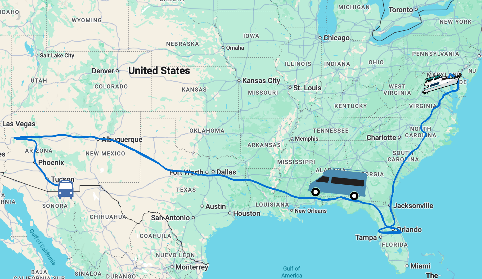
On our last post, we had just left the civilazation of Marco Island to start heading south to the Keys. We explored three amazing anchorages in the Ten Thousand Islands.
Today, we pick up the journey and share about our next two stops in Everglades National Park.
Keep in mind, this segment was in mid-August, so thus still pre-Irma – hopefully the beauty of these stops remain. Also, because we were firmly within the borders of a national park, there is no drone footage to share (it’s not allowed).
So.. on with the adventure!
This post covers August 15-17, 2017
Cruising Everglades National Park
And of course, we start off with a video version of this adventure – which we think captures the beauty and thoughts even better. This video is about 14m long and includes some geeking out about mobile internet in remote places:
Stop 1: Little Shark River

At the north end of Cape Sable deep in the Everglades, Little Shark River is a very popular anchorage for those passing through. The tributaries run for miles amongst the protection of mangroves, making it an ideal spot to ride out storms.
In fact, it’s a popular hurricane hole, and we talked to several from Marathon who took their boats here during Irma and did well. The downside is, if you get in trouble – you are very much in the middle of nowhere with no land access. It’s all mangroves, not a beach for dozens of miles.
Getting here from Russel Pass was about a 38 nautical mile cruise – our longest one-day passage to date. And all of it in the open waters of the gulf.
It was a super calm day, so calm – portions of the Gulf of Mexico were like glass.
Without a boat in sight, we let the auto-pilot do most of the driving – while keeping a constant glance on the horizon (now try THAT with an RV!)
While underway we got chores done (cleaning, work, etc), had lunch together on the flybridge and even turned off the engines for a bit and just floated while we skinny dipped off the swim platform (with swim lines, of course).
It was a simply marvelous and relaxing passage.


")
We arrived to Snake River and took the first anchorage at the mouth – since it was calm, we really didn’t need to head further in for protection. But much of Snake River is wide and deep enough for larger boats.
After we felt secure with our anchoring, we dropped the dinghy and went exploring. We ended up puttering around for over 8 miles – and saw dolphins, turtles and lots of birds. But not a single shark or alligator (we’re sure they were there).
We arrived back to the boat just in time for a glass of wine with sunset and then discovered who the REAL little sharks are! Those darn mosquitos were out in full force. We watched them bounce off the glass trying to get at us. But not a single one got inside and we enjoyed the sunset through the windows.
All and all, a fantastic stop – but with no where to go ashore, we were itching for our next stop (or maybe that was the mosquitos bites?)
Geek Out Time!
Just skip ahead to Stop 2 if Tech Stuff isn’t your cup of tea 🙂
Mobile Internet Report @ Shark River
This is the stop we had anticipated having no cellular connection, and was a big part of our acquiring a Garmin inReach Explorer+ for added connectivity (we have been loving the weather & tracking features, our Patrons have access to track us in real time).
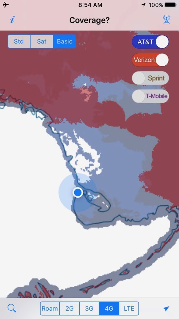
All of the Active Captain reviews said not to expect any signal – while our own Coverage? app showed there should be some AT&T HSPA+/4G signal around. We had no expectation of any coverage to even be possible for Verizon, T-Mobile or Sprint.
However, as best we could determine we’d be at least 17 miles from the nearest cell tower in Flamingo.
Signal Challenge accepted.
None of our AT&T devices on their own could get a signal. And none of our other carrier’s devices were able to get online either (as expected).
But we did try the following signal enhancing tricks with some success:
-
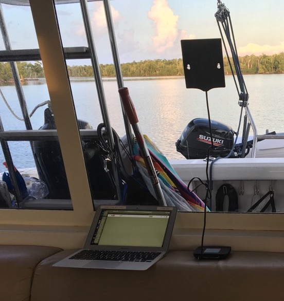
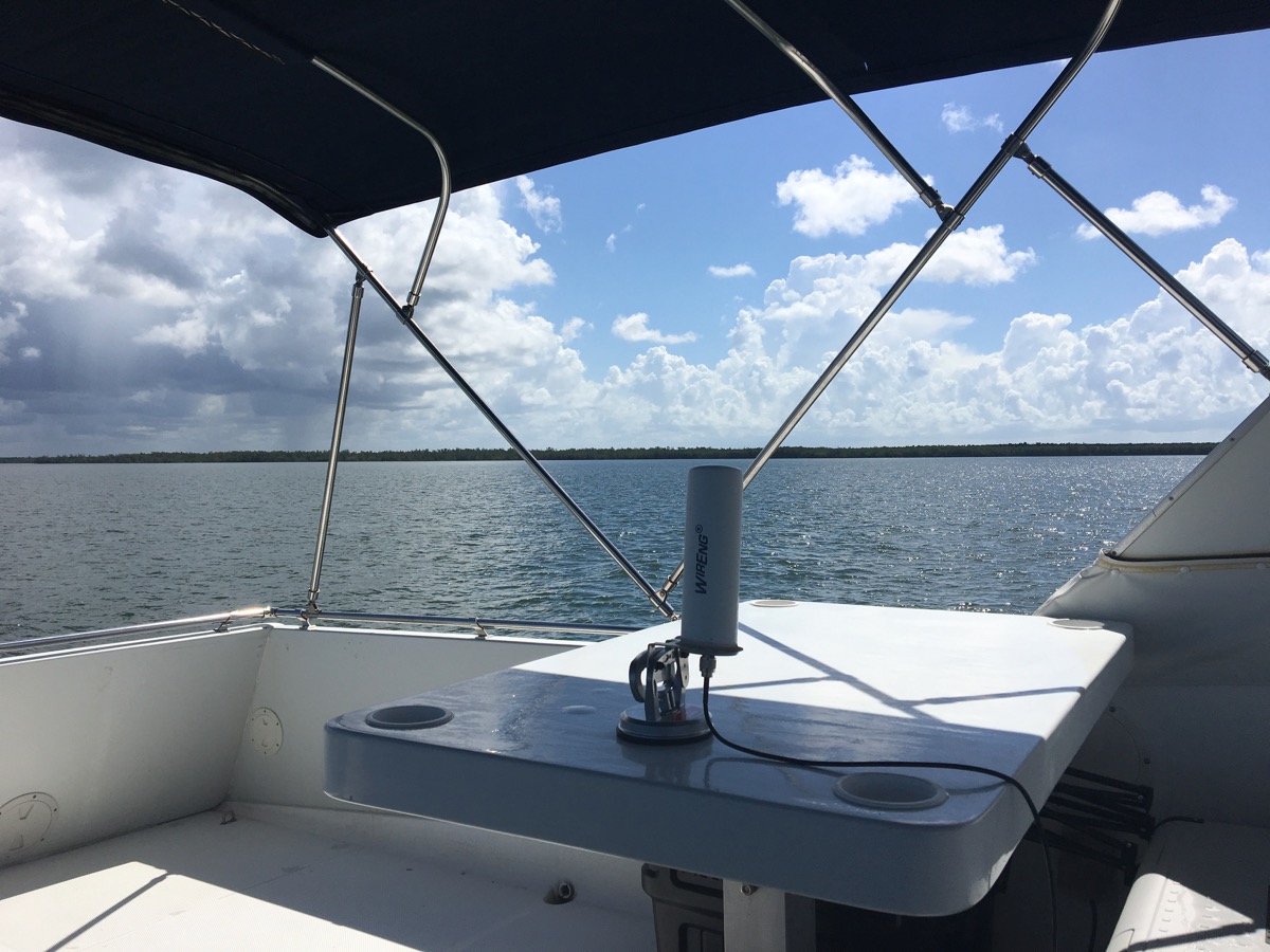
This portable suction cup antenna is one of our top performers! Netgear MIMO Antenna plugged into our AT&T Unite Explore hotspot: When the sun was just right, we were able to latch onto a 4G signal from time to time long enough to check e-mail, get weather reports and touch base with our staff. But, since this antenna is directional, everytime the boat swung around the anchor we had to re-optimize the placement. Overall, we love this little antenna. For just $27.49 on Amazon, it’s a worthwhile compliment to any mobile internet arsenal that includes mobile hotspots with dual antenna ports.
- weBoost 4G-X Booster: We tried our top pick cellular booster (our review) in this location with both the default 4″ mag mount antenna and our favorite omni-directional higher gain BoatAnt with mixed results. It wasn’t able to get the HSPA+/4G signal, but did get some very unexpected LTE signal. Download speeds were fine, but upload was near zero – which makes any surfing near impossible.
-
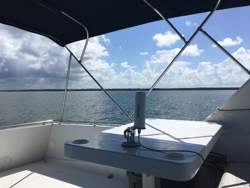
Our long favorite BoatAnt omni-directional antenna for RVing – actually on a boat finally – temporarily mounted with a suction cup mount from TechnoRV. BoatAnt plugged directly into the primary port of the Unite Explore: Since the BoatAnt is omni-directional – it doesn’t need aiming like the Netgear MIMO. However, it’s only a single antenna not MIMO (Multiple In, Multiple Out). But it’s higher gain worked quite well to get a stable enough signal to check e-mail and weather in the morning. We left this running for the entirety of our cruise down Cape Sable with a pretty solid connection offshore.
Bonus Note: AT&T currently has an Unlimited data plan that is unlimited (just subject to network management) available on their Unlimited Plus account for hotspots only. In the past couple of weeks, there has been a LOT of uncertainty about the carrier continuing to activate these lines. It seems they may still be allowing it for now.
If you’re interested, we recommend checking out our AT&T Mobile Hotspots ”No Longer Eligible” for Unlimited Data Plans article where we’ve been tracking this most of this month. This is currently one of our top pick plans available for travelers.
 For more on mobile internet for RVers and Cruisers – that’s our day job, tracking & testing this stuff over at the Mobile Internet Resource Center.
Start with our free Overview Guide to Mobile Internet to get up to speed on the basic options. Or if you’re ready for more advanced reading on signal enhancing, we have a guide to Optimizing Cellular Data Performance (part free, part member exclusive).
And just launched exclusively for our premium members – who fund all we do – we have a brand new Mobile Internet University that walks them through our guides from beginner to connected.
/Geek Out
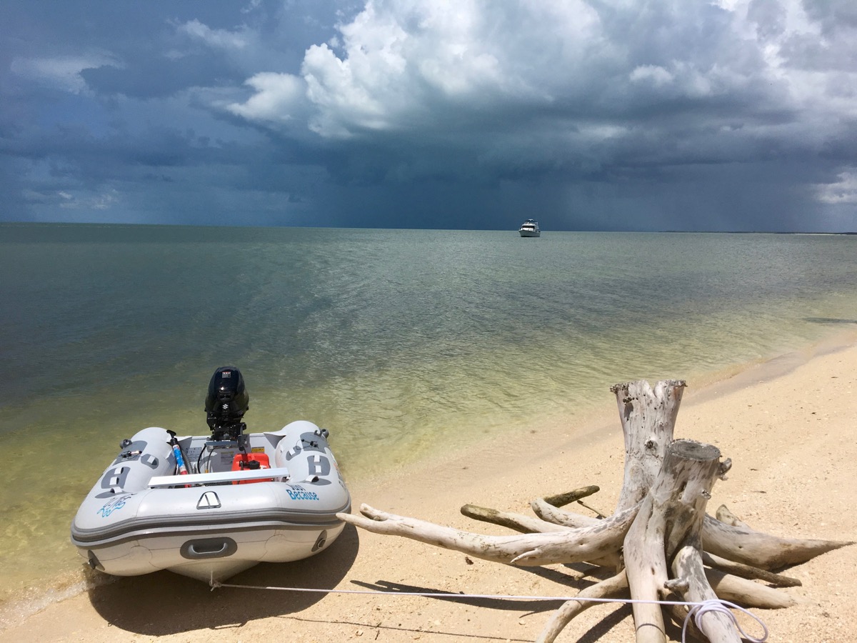
Stop 2: Cape Sable – Land Ho!

We were so ready at this point for land. Any land. Any land where we could walk more than 47′ continuously.
It had been 6 days since we had seen civilization, and aside from a couple of short beach landings – the stir crazy was setting in.
We found an anchorage off the tip of southern Cape Sable with reports of a long sandy beach to wander on. The cape had several reviews in Active Captain as being well protected from all but west winds. With the winds coming from the east, the lack of protection from the west should have been no concern (yes, that’s intentionally placed foreshadowing).
We anchored off shore with 5′ of water below us. Once we felt secure with our anchoring, we went ashore with the dinghy.
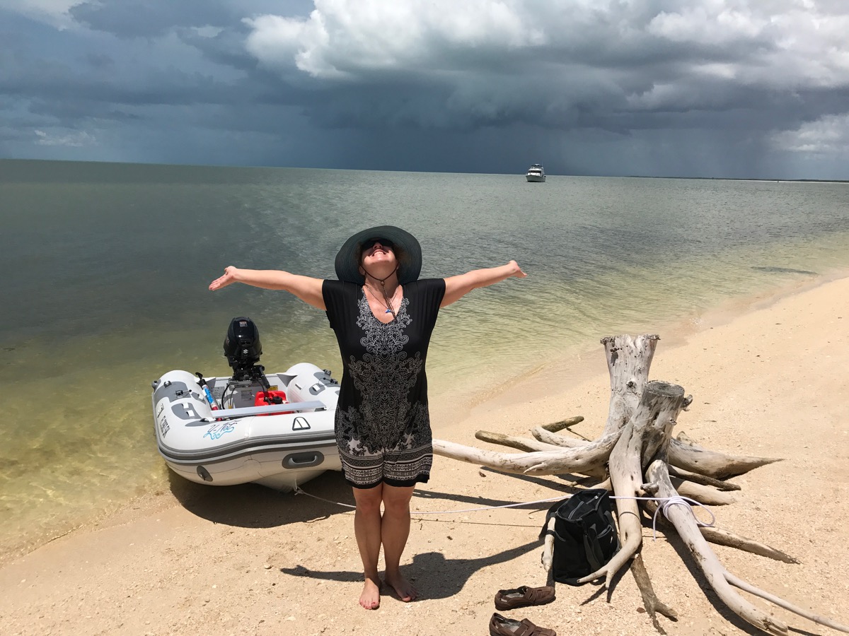
LAND HO!!
Oh my goodness did it feel good to walk! Even if I had to cover up in my shawl and hat to keep the sun off and bugs away. We walked and we walked and we walked.
We went back to the boat, took a swim and noticed we had only about 2′ of water now below the boat at low tide. Thankfully no waves to be concerned with, it was flat seas around us and the tide was rising.
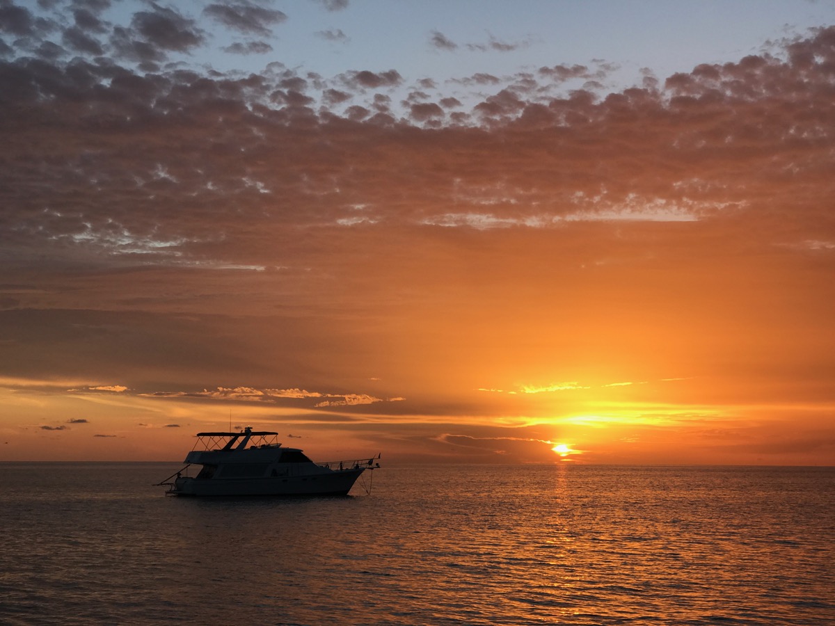
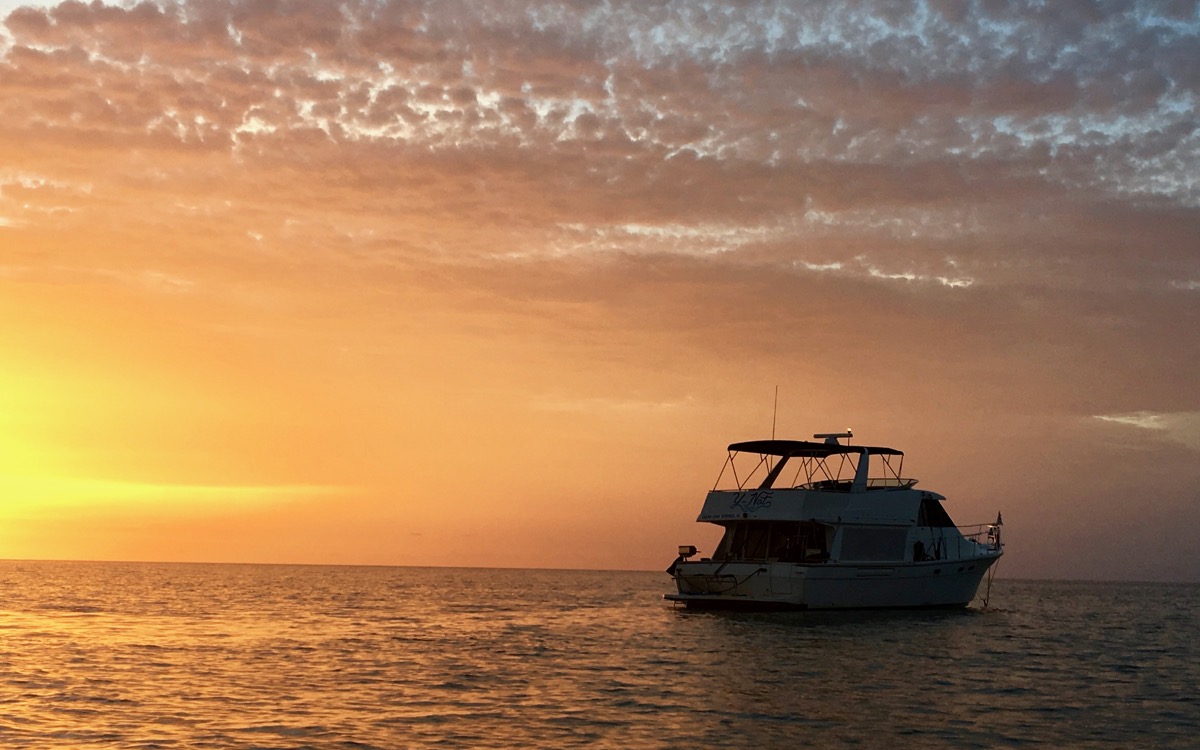
The sun started setting, and it was just too spectacular to ignore. I told Chris I was deploying the dinghy and going ashore (he hopped in with me). I just knew this would a rare photo moment:
We walked the beach some more until we could no longer stand the huge biting flies, and went back aboard Y-Not and prepared dinner. We settled in for a streamed movie or TV show (I forget which now), as we had plenty of bandwidth.
We check our Storm App regularly and had noticed a few pop up thunder cells that were previously unpredicted. We saw lightening lighting up the sky all around us. But radar predictions kept showing all cells staying well away from us.
We turned on the VHF radio to channel 16 just in case however – where emergency communications happen. And there was a warning the Mariners, advising everyone to ‘go down below’.
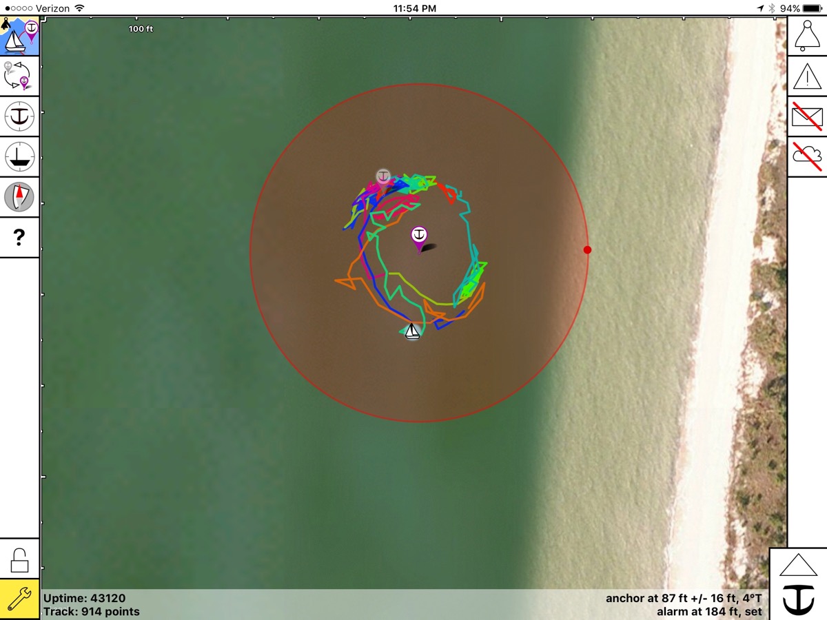
Sure enough, all the worst of the storms stayed well way from us – with just some rain and wind that kept us swinging on the anchor.
But after the cells left it kicked up the seas and sent large waves our way. The winds had us pinned parallel to shore. And as the waves hit the shore they ricocheted right back at us.
For about 30 minutes we were taking waves from both sides at the beam – causing the boat to pitch left, then right, then left, then right.
We were super happy it was high tide and we knew we had at least 5′ below us of wiggle room before bouncing off the ocean floor.
It was pretty scary, and we couldn’t think of a single thing we could reasonably do at this point to ‘fix it’ (if you have ideas, please to let us know!). Going out on deck during this to raise the anchor and try to spin the boat by engine to get a better angle seemed gutsy at best, deadly at worst.
Knowing the storms had passed, that things were getting better and this was just ‘unsettled seas’ that would soon dissipate – we rode it out while planting our butts securely on the couch with Kiki.
That evening left us with a firm reminder on just how quickly peaceful and tranquil can turn to terrifying. A lesson that will carry with us far into the future in our anchorage selection.
We left in the morning, ready to get to the Keys already.
Great Loop Log (8/17/2017)
- Distance: 193.9 nm
- Stops: 14
- Marina Nights: 97
- Anchored Nights: 14
- Bridges : 9
- Locks: 0
Other Travel Posts in this Series:
- The Great Loop: South to the Keys (Part 1) — Ft. Myers to Naples
- The Great Loop: South to the Keys (Part 2) – Naples to Marco Island
- The Great Loop: South to the Keys (Part 3) – Cruising Ten Thousand Islands
- The Great Loop: South to the Keys (Part 4) – Everglades National Park — Little Shark River & Cape Sable
- Sometimes Nomads Need to Grow Some Barnacles (Two Months in Fort Myers)
- Starting the Great Loop — First Adventure: Punta Gorda, FL to Fort Myers, FL
View all our Great Loop Posts
on our Interactive Map!
Current Status
We reported last time that we were making preps to finally leave Marathon (post Irma), which we did last Monday and enjoyed two awesome anchorages. But with iffy weather all along the way, we’ve only made it about 50 miles north to Tavernier – where we just rode out Tropical Storm Philipe (what, are we a storm magnet?!?!).
We sought dockage at a marina in a protected harbor, and aside from some gusty winds – it’s been pretty much a non-event for us.
We got a weekly rate (cheaper than 3 days), so we have flexibility to stay a few days as needed to wait out the next ideal weather window to continue northward up the ICW.
We aim to arrive to Ft. Pierce sometimes in mid-November to rendezvous with our project manager to begin BOAT PROJECTS!
Chris and Cherrie. Here we are on the Tenn Tom in Mississippi listening by VHF radio to the number of transit vessels passing thru the lock headed for winter dockage in Florida. We envey your exciting adventure. Maybe one day you will pass our way and we can share a glass of wine.
It’s all so beautiful! Makes me feel like I’m on a vacation with you two! <3. Thanks very much for all you share with us!
What a life! The awesomeness just continues! Just love getting to enjoy a peek! Mazel Tov!
Thanks so much for coming along for the journey!
Gorgeous views! Love seeing your life aboard the boat as well. We felt like smoke magnets in September, seeming to find it everywhere we turned. Hope the storms are finally out of your path.
What a crazy season it’s been with wildfires, hurricanes and earthquakes.
Lots of big wide smiles from you two! Happy for you.
Aside from the storms, we’re really digging the boating lifestyle 🙂